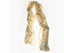
The Father of the Water's scarf is made of beautiful lightweight chiffon silk with a stunning drape.
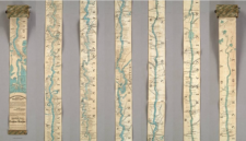
It is based on an 1866 "ribbon map" by Coloney & Fairchild featuring the Mississippi River from Vicksburg through Natchez, Baton Rouge, and New Orleans - straight through to the Delta.
While the original "ribbon style" map in the 1800s covered the entire length of the Mississippi (2,600 miles) and was first sold to passengers on steamboats, the scarf starts just above Vicksburg and shows its fluidity and the fluctuating nature of the course as it and travels down to the Gulf of Mexico.
It details the tributaries, towns, railroads, landings, and other geographic information with great clarity.
Ribbon maps were an interesting, new panoramic way of looking at the terrain and recalled the panoramic craze in the early 1800s. This original map featured the entire river as one continuing strip 11 feet long, which was mounted as a scroll in a little case to uncurl.
